Skip to content

About Carsten

Hi, my name is Carsten. As long as I can remember I like nature in all its forms and colours. I like hiking, cycling and travelling all over the world. Furthermore I am interested in photography. Here I want to share my interests and experiences with you.

The Stuibenfall Waterfall is with a height of 159m the highest waterfall in Tyrol - and it has a fixed rope route which goes along the left side of the waterfall. It gives you a great view on the waterfall all the time while climbing up 300m.

We took the bus to Umhausen, from there we followed the signs saying 'Stuibenfall' until we arrive at a small shop and parking area. From there you walk through a forest for about 20 minutes until you arrive at the beginning of the via ferrata. From the start you can already see the great waterfall.

The first part of the via ferrata is a ropeway. This was our first route with a ropeway so it was quite exciting! Then you''ll find many fixed ropes.

Take a break and enjoy the waterfall from high above!

The last part is another more difficult ropeway. This one is really good, because it''s above the waterfall and for sure you''ll get wet 😀 This is a nice way to cool down on warm days 😉

After finishing the via feratta we enjoyed the waterfall and then took the normal way back to the little shop and the parking area.

In August 2009 we did our first trip to the Oetztal. The Oetztal is very famous for skiing in the winter. But it was summer and we decided to go hiking - and to go on a mountain which is higher than 3000m for the first time! We took the bus to Umhausen which is a small village with a nice waterfall. From Umhausen we start the ascent to the Erlanger Hut. In the beginning it is a long walk through a forest... After a few hours we arrive at Vordere Leierstalalm (1798m) where we take the first break.

After this sign you can already see the Erlanger Hut. But it is still a long way up... The first thing to do after arriving at the hut - order a Skiwasser! Right behind the hut is the beautiful Wettersee 🙂 After a little break we continue walking in the direction of the Wildgrat (2971m). The view of the Wettersee is so great! After enjoying the great view we go back to the Erlanger Hut to have some food. Really tired we went to bed and got up quite early the next morning, because we wanted to go up Fundusfeiler - our first ascent over 3000m.

Around lunchtime we arrived at the top (3079m) and enjoyed blue sky and sunshine. We continued to walk to the Frischmann Hut and had great food and stayed there over night. The next morning we started the descent back to Umhausen. All in all this was a great tour in a beautiful landscape.

We stayed at a camping site in Grän. From there we took the Füssener Jöchle railway up to the mountain. There we started to walk to the beginning of the Friedberger Klettersteig. We had a great view down to the valley with the blue Haldensee. From top of the Schartschrofen we went down the Friedberger Klettersteig. From there we continued to walk up the Rote Flüh. From the summit of the Rote Flüh we could watch some climbers on the Gimpel. That looked scary. Then we walked back down to the valley and wanted to take the bus back to Grän. But there was no bus to Grän! We were already too late. We asked some other hikers which were so kind to drive us back to Grän with their car.

We start our trip in Oberjoch which is the highest village in Germany. To get to the entry of the Salewa Klettersteig you can either use the cable car or walk. We decided to walk. When we arrived at the beginning of the via ferrata there were many people. The via ferrata is quite new and was not so difficult. Because of too many people there was a jam during the route and often we had to wait up to 10 minutes until we were able to continue.

Nevertheless we enjoyed arriving at the Iseler (1876m) and had a great view down to the Tannheimer Tal.

From the Iseler we continued to the Kühgundspitze (1907m). On this way we met only a few people - I think most of the people who did the ferrata took the cable car back down to the valley after a short break on top of the Iseler. So we enjoyed blue sky and a great view without so many people around us.

About an hour later we arrived back at Oberjoch. From there we drove to Grän which is about 10 minutes away. There we wanted to do another fixed rope route called Friedberger Klettersteig.

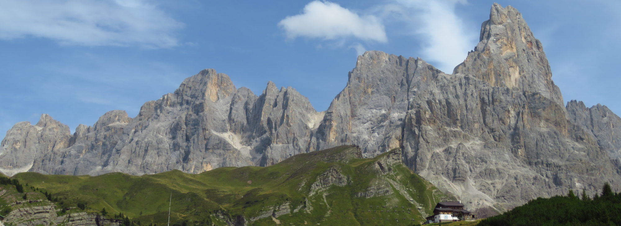
End of june 2008 we decided to visit the Rosengarten. Form Germany, we take the train to Bolzano. After a few minutes walking we arrive at the bus station. We take the bus going to Vigo di Fassa and get off at station Karerpass. Our first destination is the Paolina Hut (2125m).

After a short break we continue walking to Rifugio Fronza (Koelner Hut) (2337m). There we take a longer break eating a cheese and bread. Our plan is to pass the Tschager Joch and then to go further to Rifugio Vaiolet.

However, due to lots of snow in the above areas we change our plans. We head back to Rifugio Fronza and walk to Rifugio Roda di Vael (Rotwandhütte) (2283m). On that way we pass the eagle monument which remembers Theodor Christomanos.

Arriving at Rifugio Roda di Vael it turns out that this hut is currently closed due to renovation (an hour ago we met a man who told us that he is just coming from Rifugio Roda di Vael - probably for him it was just a minor detail that the hut is currently closed....). This is the moment we learned to always call a hut before we go for it... - at least in Italy. We decided to proceed to Rifugio Ciampedie which was approximatly 90 minutes away. On our way we see some quite interesting rock walls.

Quite exhausted, we finally arrive at this really nice hut. The next morning the weather is as good as it can be. Our todays goal is Rifugio Antermoia (2498m). We plan to go to Rifugio Gardecia and then take the Scalette via ferrata to Passo delle Scalette, 2348m. From there we want further proceed to Rifugio Antermoia. The first part of the way from Rifugio Ciampedie to Rifugio Gardecia is a 30 minutes walk. We follow the signs. The road turns into a small path which leads us through wood and rock up the hill.

After maybe an hour the wood disappeared. We reach the beginning of the Scalette via ferrata. In front of us lies a more or less steep path through the rocks. To the left and to the right we see large walls of stone. Technically, the via ferrata is quite easy - but still exhausting since it is going upstairs all the time. Only the last part is secured by a steel rope.

After an hour we arrive at Passo delle Scalette, 2348m. We continue walking on a plateau for some time until it becomes steeper again. Arriving at the top, we can already see Rifugio Antermoia. To the left we see the Antermoia Lake.

After approximately 5 hours, 750m up and 250m down we finally arrive at Rifugio Antermoia. We are so hungry that we almost can't wait for dinner. Finally, we both have two different meals 😀 The beds in Rifugio Antermoia are quite nice since they have three levels... we sleep like being dead.

Since we really liked Rifugio iCampedie we plan to go back there the next morning. We plan to pass the Grassleitenpass, the Grassleitenpasshütte (2601m), Rifugio Vajolet (2243m) and Rifugio Gardecia heading back to Rifugio Ciampedie.

First, we pass Lake Antermoia. Until we reach a sign which is still surrounded by snow. Passing along we leave another plateau beyond us. Finally we arrive at the Grassleitenpass from where we can already see the Grassleitenpasshütte.

From up here we follow the signs back to Rifugio Ciampedie. There we again had a beautiful evening and a great lunch 🙂