Skip to content

This morning we left Abries and actually we wanted to go to the Lacs du Malrif. Besides us there we about 100 other people who choose the same direction for today. By walking in the direction of the lakes we got some impressions of the Queyras - it is very green! Not so much rock, but a lot of grass and flowers. So we walked up along a small church and then through a nice valley along a river. From there it goes up trough grass many hundred metres. But after some hours the sky turned from blue to white and clouds began to form. It looked exactly like one situation where a storm arrived last year! So we both decided that it is better to return. So we walked back the same way we came. At the small church we stopped and had a picnic. By this time the sky was blue again! So we stayed there the rest of the afternoon lying in the sun. Then we went back to Abries and from there we took the bus to Ville Vieille.

Here are some tips when you want to go to the Queyras national park:

  • you will be the only foreigner - 99% of the other people you meet are French
  • you will be treated as a foreigner, like you are coming from Germany you will always be referred to as "Allemand", people are not very helpful to you
  • nobody will ask you if you understand, people will just continue to talk in French, other languages are not accepted
  • accommodation is not very comfortable, we stayed in many mountain huts and simple accommodations before, but the ones here were really bad
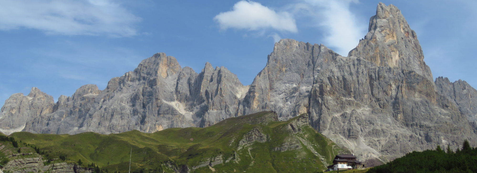
  • a lot of grass and green, if you expect rock you better stay on the Italian side around Monviso
  • most of the bus connections you have to reserve 36 hours in advance! otherwise there will only be one bus a day (or even not that), bus time tables and reservations can be found here: http://05voyageurs.com/
  • it is hard to find food which does not consist of meat, which is not good when you are vegetarian

Ok, maybe this sounds not so good and somehow like discriminating French people, but it was what we experienced.

After three days in France we decided to go back to Italy where we experienced friendly, helpful people.

Because the weather in the Alps was mostly very bad this summer we decided to hike through one of sunniest parts of France - the Queyras.

To go there you have two options - take the TGV trough France (very expensive) or go to Torino in Italy (cheaper) and then cross the border hiking along the Col d'Abries.

When you want to go into the Queyras national parc from Italy a good starting point is the small village Ghigo di Prali. So from Torino there is a bus to Perosa Argentina and from there a continuing bus to Ghigo Prali. So what is quite confusing is that in the maps the village is marked as Ghigo. But bus timetables and signs say Prali. So don't be confused, it is the same. We get off at the last stop. If you want to stay in Ghigo there is a posto tappa.

To go from there to France we start early in the morning and walk in the direction of Rifugio Lago Verde. At first the path goes through a forest, but later on you have a good view around. Just before the Rifugio Lago Verde we keep right and climb up to the Col d'Abries which is 2658m high. From the Col d'Abries you have a great view - one side to Italy and the other side to France. For being so high it is very green and a few hundred metres down we can see many flowers and grass. Because huge clouds are coming we go quickly down. Shortly before reaching Le Roux we walk along a river which is very beautiful. The small village Le Roux is not very spectacular and so we walk directly to Abries. Actually Abries is quite a nice small town, but there is far too much car traffic! We stayed in a gite called Le Villard. The gite was not comfortable and we were happy to leave the next morning.


Spontaneously we decided to stay one more day in Oberstdorf than we have actually planned. The weather forecast was quite good and so we decided to go for another hike. Beside hiking we wanted to try some of the things we have learned in the photography lesson with Heinz Zak the day before. We decided to hike from Oberstdorf to the Fiderepass Hut, have a drink and then hike back to Oberstdorf. We took the "Panorama Path" up to the Fidere-Scharte and from there down to the Fiderepass Hut. The path from the Fidere-Scharte to the Fiderepass Hut was still full with snow. Especially the upper part was quite steep and not so nice. However, we finally arrived at the hut and ordered something to drink. It was so nice to sit up here in the sun watching all the mountains aground and enjoying a cold beer. This is always the moment when you can forget the hurting feet 😉 From the Fiderepass Hut we walked down to the Fellhornbahn Talstation (about 3:15). From here we took the bus back to Oberstdorf.
All in all it was a nice trip with great weather and some nice photo spots. Just around the Fidere-Scharte there was a little more snow than expected. We are already looking forward to be back in the mountains.

Again we were visiting Oberstdorf for a few days - this time to visit a photography course with Heinz Zak - a famous mountain and landscape photographer. We arrived one day earlier and decided to make a short hike in the afternoon. Even if we have been there before we decided to hike to the Rubihorn summit again. From Oberstdorf and back it takes something between 4 and 7 hours - depending on the walking speed. Most of the path upwards was just a zig-zag and the sun was burning quite much. After about 2 hours we arrived at the Rubihorn and took a long break. Actually we were expecting quite a lot of people up there since it was Sunday and the weather was nice but actually there were just six or seven other hikers. At the summit we were able to observe daws.
The path from the summit down to the Gaisalpsee took about 45 minutes. Here we made another break and enjoyed the sunlight dancing on the lake. From the lake we further followed the path downwards to the Gaisalpe. After about 1 hour we arrived at the Gaisalpe and enjoyed a cold apple soda 🙂 From here we were heading back to Oberstdorf (about 90 minutes). We think the Rubihorn is always worth a hike. Especially after a long winter break the Rubihorn is always a good starting point to get used to the mountains again 🙂

GPS GPS: gpx | google maps

Not far from our home is the HW5 hiking trail which goes form Pforzheim to the Allgäu. On this sunny Saturday we decided to hike one stage of this trail - from Herrenberg to Unterjesingen. This stage was supposed to be a "panorama" trail with great views into the Ammertal. Basically this is true - there are places from where we had a great view - however about 13km of the in total 21km long trail we just walked through the Nature Reserve Schönbuch forest without having a wide view. This part of the trail was quite boring compared to our regular trips through the Alps. Anyway, it was ok for a day trip which was just round the corner.

Not far from Herrenberg we arrived at the Herrenberg Waldseilgarten which is a kind of high rope course. Up to here it was a very nice path. The next kilometers were more or less in the forest. The last two kilometers before we arrived at Hohenentringen Castle were quite nice again. From here we had a very nice view down to the valley. The Hohenentringen Castle was a very nice place where we had something to drink and a piece of apple pie. After about 20km walking we really enjoyed sitting in the sun. After a long break we walked down to Unterjesingen from where we took the Ammertalbahn back to Herrenberg.